About Us
DigitiseThis was established with the specific goal of providing archaeological consultancy firms with a specialized on-site archaeological surveying service. Our company, based in Kent, primarily operates in the South East, where we have been involved in archaeological projects of various types and sizes since 2006. We utilize the latest surveying technology in both commercial and research archaeology, offering competitive rates for both. We also provide off-site post-excavation digitizing and CAD work to produce high-quality graphics for archaeological reports and publications.
Why Choose Us?
Flexibility and Reliability
We are a specialist company dedicated to archaeological surveying and associated graphics production. We adhere to standard archaeological drawing conventions during digitization but have always maintained flexibility to accommodate the diverse presentational styles of our clients.
The unpredictable nature of archaeological site work means that features often appear unexpectedly (such as the discovery of a burial). We are available at short notice to conduct on-site surveys.
Close communication between ourselves and our clients is crucial to ensure we understand their exact requirements. We are easily accessible, by phone or email, for any queries or necessary additions or alterations.
Affordability
We recognize that some large archaeological consultancy companies have their own in-house surveying teams, but we offer an alternative option by providing surveying services as needed, providing a more cost-effective solution.
We also offer competitive rates to smaller and medium-sized companies who require surveying but may lack their own surveying expertise, equipment, or the time to undertake it.
We understand that funds available for non-commercial research archaeology may be limited. Therefore, we offer reduced rates for groups and individuals undertaking this type of work.
Local and National Reach
For large archaeological companies not based in the South East, we offer an alternative to sending out an in-house surveyor long distances to cover sites far from their offices. This can be particularly beneficial for small sites requiring only a handful of points, where spending a significant portion of a day traveling becomes uneconomical.
For companies outside the South East, we are available for on-site surveys, digitizing, and graphics production, which can be sent remotely via email or post.
Meet the Team

Jonathan Madden BA
Before establishing digitisethis in 2006 with my brother, I worked as a land surveyor for a chartered survey firm in Kent for five years. During this time, I gained significant knowledge and experience in using GPS, TPS, HDS, and AutoCAD. I also have several years of experience as a field archaeologist.

James Madden BSc MSc
In addition to co-running digitisethis, I have been working for various archaeological units across Kent and the South-East for the past 10 years. More recently, this has included work as a project officer, managing large archaeological sites. I also worked for a small chartered survey firm before setting up digitisethis.
While archaeologists have been recording sites and landscapes using traditional surveying techniques for many years, advancements in technology have enabled surveyors to map archaeology in real-time much faster and more accurately than ever before. Our company provides the latest surveying technology as described below:
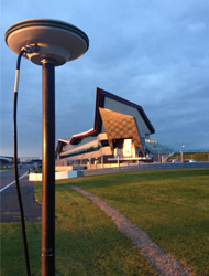
We primarily use a Leica GPS Rover 1200 to ensure that archaeological plans are georeferenced according to the Ordnance Survey National Grid. This is a standard requirement of archaeological specifications issued by local authorities as a condition of planning consent. However, we also use GPS extensively to accurately map the position (and provide levels) of individual archaeological features and finds. This allows us to produce highly accurate and detailed pre or post-excavation site plans. Where required, we use GPS to set out site boundaries or evaluation trenches and have even used it to locate features seen from aerial photographs.
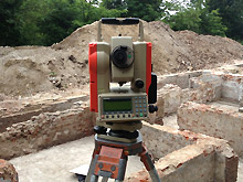
When dense vegetation or buildings disrupt the satellite signal, a total station is used to accurately map archaeological features, producing the same detailed site plans as with GPS. We also use a total station to set out accurate site grids. Additionally, we have used the total station to assist in recording historic buildings and walls to produce elevation drawings.
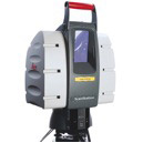
When recording above-ground archaeology or archaeological sites of special importance, we can employ the use of a High Definition Scanner. This produces not only impressive, spatially accurate 3D visualizations but also data for detailed contour mapping (see projects section for an example).
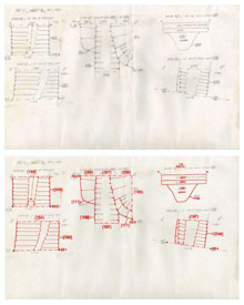
In addition to our on-site survey work, we use AutoCAD software to digitize hand-drawn plans and sections that have been produced by archaeologists in the field. We do this by scanning and electronically ‘tracing’ them using CAD, thereby providing a digital copy of these drawings. Using standard archaeological drawing conventions, we produce scaled drawings (including site plans, phased plans, and sections) for archaeological reports and publications. We can create PDFs of our graphics work and/or print paper copies at any scale or paper size. These may be laminated if desired.
- Competitive Pricing
We offer competitive pricing and strive to provide the best value for your investment.
- Free Estimates & Consultations
We are committed to environmentally responsible practices, minimizing our impact on the environment.
- Commitment to Quality
Rest assured that your project is in capable hands, as we adhere to the highest industry standards.